↓
 

Hoover Land Surveying

...professional land surveyors in the Hoover, Alabama area.

Hoover Land Surveying
  • Home
  • ALTA Title Survey
  • Boundary Surveying
  • Construction Surveying
  • Drone LiDAR Mapping
  • Elevation Certificate
  • Land Surveying
  • Topographic Survey | Topo Survey
  • Blog
  • Contact Us
Home→land surveying→How to Read a Survey Plat  →How to read a survey plat property boundary map

Image navigation

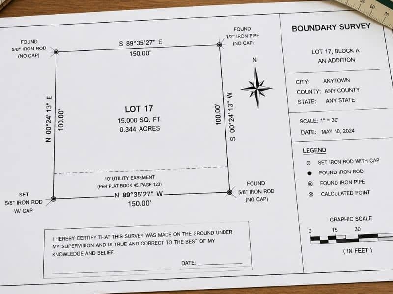
How to read a survey plat property boundary map

Published May 21, 2026 at 800 × 600 in How to Read a Survey Plat 

Image navigation

Get Quote Button
Order an ALTA Survey Hoover AL
© 2020 Boxer Survey USA
HooverLandSurveying.com
Address: Hoover, Alabama
Phone: (205) 402-8050

Web Development and SEO by:
AuburnBusiness.com, LLC


Privacy Policy | Terms of Use

The owner of this website, Boxer Survey USA, provides coordination of professional land surveying and engineering services in all 50 states. The professional surveying and engineering services provided to you will be conducted by fully licensed professionals in your state.

&nbsp Privacy Policy
↑