↓
 

Hoover Land Surveying

...professional land surveyors in the Hoover, Alabama area.

Hoover Land Surveying
  • Home
  • ALTA Title Survey
  • Boundary Surveying
  • Construction Surveying
  • Drone LiDAR Mapping
  • Elevation Certificate
  • Land Surveying
  • Topographic Survey | Topo Survey
  • Blog
  • Contact Us
Home 1 2 >>

Post navigation

← Older posts

Why Homeowners Should Keep Their Elevation Certificate Up to Date

Hoover Land Surveying Posted on June 25, 2026 by HooLaSuJune 21, 2026
Surveyor measuring elevations near a home to prepare updated elevation certificate information

A flood insurance review can bring a surprise, even for homeowners who haven’t changed a thing about their property. The home looks the same. The yard looks the same. Yet the price quote looks completely different from five years ago. The cause is rarely something the homeowner did. The flood maps or risk models behind that number have likely changed instead.

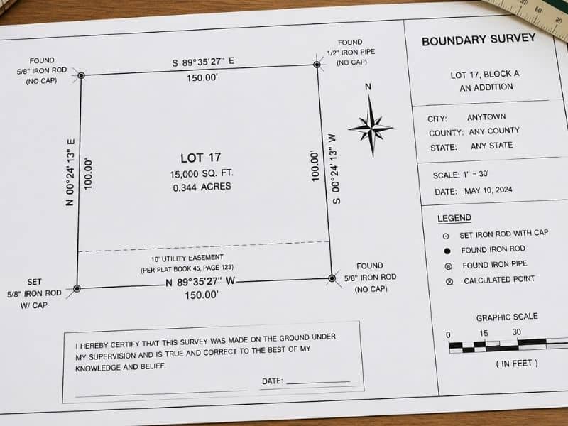
An elevation certificate is the document that usually sits at the center of this. It shows exactly how high a home sits compared to flood levels nearby. That one detail carries more weight than most homeowners realize until they actually need it.

Flood Risk Ratings and Insurance Requirements Can Evolve Over the Years

A flood zone label feels permanent once a homeowner gets used to it. It isn’t. Flood maps get updated now and then as agencies collect better data on rain, rivers, and coastal change. A home that sat outside a high-risk zone a decade ago can land in a new zone after a map update. Nothing on the property itself has to change for that to happen.

Rating methods shift too, apart from the maps. Insurance companies now weigh more small property details instead of just one flood zone label. Two homes on the same street, built to similar standards, can end up with different prices. The gap often comes down to small things like exact height, distance to water, and how the home was built.

Weather adds another layer of change. Some places that once saw mild rain now see harder storms. Risk models shift over time to match that. None of this happens overnight. Most homeowners never see one big jump. They just see price quotes that look a bit different each year. Checking flood risk data every few years, instead of assuming it stays the same, helps homeowners stay ahead of these shifts.

An Elevation Certificate Documents Critical Building Elevation Information

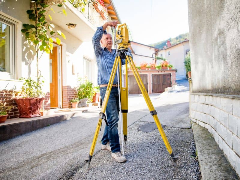
An elevation certificate records one clear fact. It shows how high a home’s lowest floor sits compared to the flood height set for that area. A licensed surveyor or engineer takes the measurements and fills out the form. The format is standard, so insurers and lenders know exactly what they’re looking at.

This document matters because it swaps guesswork for a real number. Two houses on the same street can carry very different flood risk based on how high each one was built. That’s true even if they sit at roughly the same ground level. A house built two feet above flood height acts very differently in a flood than one built two feet below it. The certificate puts an exact number on that gap.

Insurers use this data to set fair prices, instead of one flat rate based only on flood zone. Lenders check it when reviewing loans for homes near flood risk. Homeowners gain an honest record they can point to, instead of relying on memory when a flood question comes up.

Homeowners May Need an Elevation Certificate During Refinancing or Property Sales

Certain moments tend to bring elevation certificates back into the picture. This happens even for owners who haven’t thought about flood insurance in years. Refinancing a home loan on flood-zone property often leads a lender to ask for current paperwork. That’s especially true if the old certificate is missing.

Selling a home brings up the same issue. Buyers and their lenders often want to see elevation details before closing a deal. This matters most if the property sits near a flood zone on the map. A seller who already has a current certificate can answer questions right away. A seller without one often has to scramble for a new survey during a tight closing window.

Insurance companies sometimes ask for updated certificates too. This often happens after a map change shifts a property’s zone. A current certificate, ready ahead of time, makes the whole process move faster. There are fewer delays from waiting on a surveyor at the worst possible moment.

Improvements and Property Changes Can Affect Future Insurance Conversations

A home rarely stays exactly the way it was when its first elevation certificate was done. Additions get built. Areas beneath raised homes get enclosed. Garages turn into living space. Each change can affect how a property gets judged for flood risk later, sometimes in ways homeowners don’t expect.

A few specific changes tend to come up most often:

  • An addition built at a different height than the original home
  • A space beneath a raised home enclosed for storage or living
  • Major fill or regrading added around the foundation over time

Keeping records of these changes, along with the original certificate, gives homeowners a clearer starting point. That helps later, when insurance or lending questions come up. A home changed since its last certificate may need new paperwork to match what’s actually been built.

Keeping Current Elevation Information Supports Long-Term Property Planning

Elevation information stays useful well past the moment a homeowner buys insurance or closes a sale. Anyone planning a big renovation benefits from knowing their home’s height details first. That detail can shape choices about foundation height, equipment placement, or whether flood-proofing makes sense for the project.

Homeowners looking into flood-proofing, like raising a home or adding flood vents, need solid starting data first. Without that starting point, it’s hard to know how much any given change would actually help.

This same information supports future choices too. That holds whether it means selling years down the road, or simply comparing the home to others nearby. Current elevation data turns flood risk from a vague worry into something a homeowner can actually plan around.

Frequently Asked Questions

What is an elevation certificate? 

A qualified professional prepares this document. It records key height details about a structure.

Why can flood insurance costs change over time? 

New flood maps, new rating methods, and property details can all shift the price over time.

When might a homeowner need this document? 

Buying flood insurance, refinancing, selling a home, or meeting a lender request can all call for one.

Can an older certificate still be useful? 

Yes. Old certificates can still help, though some cases call for fresh paperwork.

Who benefits from having one on hand? 

Homeowners, buyers, lenders, insurers, and real estate agents all gain from accurate height records.

Posted in elevation certificate | Tagged elevation certificate

How to Read a Survey Plat 

Hoover Land Surveying Posted on May 29, 2026 by HooLaSuMay 21, 2026
Property boundary survey plat showing lot lines, bearings, easements, and measurements on a clean drafting table

A survey plat is a detailed drawing that shows the legal boundaries, dimensions, and features of a piece of land. Most property owners receive one at closing or after hiring a surveyor, take one look at it, and have no idea what they are looking at. The lines, numbers, and symbols can seem confusing at first. But once you know what each part means, a survey plat is actually straightforward to read.

What Is a Survey Plat?

A survey plat is the official document a licensed land surveyor produces after measuring a property. It is drawn to scale, so the distances on paper match real distances on the ground. It shows where the property lines are, how long each one is, and what features exist on or near the land.

A plat is a legal document. It can be recorded with your county and referenced in real estate transactions. Understanding what is on yours gives you a clearer picture of what you own.

The Title Block

The title block is usually found in the bottom right corner of a survey plat. It contains key identifying information about the property and the survey itself.

Look for the following in the title block:

  • The name of the property owner
  • The address or legal description of the property
  • The name and license number of the surveyor who certified the plat
  • The date the survey was completed
  • The scale of the drawing, such as 1 inch equals 50 feet

The scale is important. It tells you how to interpret distances on paper. If the scale is 1 inch equals 50 feet, then a line that is 2 inches long on the plat represents 100 feet on the ground.

The North Arrow

The north arrow shows which direction is north on the plat. This helps you orient yourself when comparing the drawing to the actual land.

Most plats use one of two north references. True north points toward the geographic North Pole. Magnetic north points toward the magnetic North Pole, which shifts slightly over time. The plat will usually note which type is being used.

Once you find the north arrow, you can figure out which side of your property faces which direction. This is useful when checking fence placement, planning construction, or comparing the plat to a map.

Boundary Lines

Boundary lines are the solid lines that outline the edges of the property. These are the most important lines on the plat. They show the legal limits of what you own.

Each boundary line has two pieces of information attached to it: a bearing and a distance. These tell you the direction and length of that line.

Bearings

A bearing describes the direction a boundary line runs. It is written using compass directions and degrees. A typical bearing looks like this: N 45°30’00” E.

Here is how to read it:

  • The first letter (N) is the starting direction, either North or South.
  • The number (45°30’00”) is how many degrees the line turns from that direction.
  • The last letter (E) is which side it turns toward, either East or West.

You do not need to memorize the math. What matters is that every boundary line has a unique bearing that tells you exactly which way it runs.

Distances

Next to each bearing, you will see a distance in feet. A line labeled N 45°30’00” E, 125.50′ runs in that direction for 125.50 feet. Adding up all the distances gives you the total perimeter of the property.

Monuments and Markers

Monuments are the physical markers placed in the ground to mark the corners of a property. On a plat, they appear as small symbols at each corner. The legend explains what each symbol means.

Common types include iron pins or rods, and concrete posts. The plat will also note whether a marker was already there when the surveyor arrived (found) or placed during the survey (set). If your plat shows iron pins, you may be able to locate them with a metal detector.

Easements

Easements are shown on a plat as dashed or dotted lines running across or along part of the property. They are labeled with a description of what the easement is for and how wide it is.

Common examples include utility easements, drainage easements, and access easements. An easement line that runs along the back edge of a lot, labeled “10-foot utility easement,” means a utility company has the right to use that 10-foot strip of your land.

Knowing where your easements are helps you avoid building in spots where you do not have full control of the land.

The Legal Description

The legal description is a written paragraph that describes the property using the same bearings and distances shown on the plat. It reads like a set of directions that traces the boundary of the property from one corner to the next and back to the starting point.

Legal descriptions are used in deeds and other official documents. If the legal description in your deed does not match what is shown on your plat, that is a red flag worth investigating with your surveyor or attorney.

The Surveyor’s Certification

At the bottom of the plat, you will find the surveyor’s certification, signature, and official seal. The certification confirms that the survey was done to professional standards and that the information is accurate. Without this seal and signature, the document is just a drawing.

Frequently Asked Questions

What does “P.O.B.” mean on a survey plat? 

P.O.B. stands for Point of Beginning. It marks the starting corner of the legal description. The boundary lines are traced starting from this point and return to it at the end.

What does it mean when a plat shows a gap or overlap with a neighboring property? 

A gap means there is a strip of land between your property and your neighbor’s that does not belong to either of you on paper. An overlap means the two properties share the same area on paper. Both are errors that need to be resolved with the help of a surveyor and possibly an attorney.

Can I use my survey plat to place a fence? 

Yes. Your plat shows the exact boundary lines and corner locations. Use it along with the physical monuments on the ground to confirm placement before building.

What is the difference between a plat and a deed? 

A deed is a legal document that transfers ownership of a property and includes a written description of it. A plat is a drawn map that shows the same property visually. Both work together to define what you own.

Posted in land surveying | Tagged land surveying

What to Expect During a Land Survey

Hoover Land Surveying Posted on May 27, 2026 by HooLaSuMay 21, 2026
Land survey crew performing a residential land survey using surveying equipment

If you have never hired a land surveyor before, the process can feel like a mystery. What does the crew actually do on your property? How long will it take? What do you get when it is done?

Before the Survey Begins: What You Should Do

Before your surveyor ever sets foot on the property, there are a few things you can do to help the process go smoothly.

Start by gathering any documents you have. This includes your property deed, any past surveys, and your title insurance policy. Having these ready saves time during the research phase.

Also tell your surveyor why you need the survey. Whether you are buying a home, planning a build, or settling a dispute, knowing the purpose helps them focus on what matters most.

Make sure the surveyor has access to all parts of the property. Locked gates, pets, or blocked areas can slow things down or require a second visit.

Step 1: The Research Phase

Before any measurement happens, the surveyor spends time in the office reviewing records. This step is just as important as the fieldwork, even though you will not see it happening.

The surveyor pulls your property deed, legal descriptions, prior survey plats, and county records. They look at how neighboring properties are described in their deeds too. This helps them understand the full picture of your property and spot any gaps or conflicts before they head into the field.

This research phase can take anywhere from a few hours to several days. It depends on how old the property is, how well the records are kept, and whether any past surveys exist. Rural land with a long history often takes more time to research than a newer suburban lot.

Step 2: The Field Visit

The field visit is when the survey crew comes to your property to take measurements. This is the part most people picture when they think of a land survey.

The crew will arrive with equipment such as GPS receivers, total stations, and measuring rods. They use these tools to locate existing boundary markers, measure distances, and record features on and around the property. In some cases, they may also look for iron pins or concrete monuments that mark the corners of the lot.

You do not need to be home during the field visit, but it helps to be available by phone in case the crew has questions. If the crew cannot find a boundary marker, they may need to dig or use historical records to figure out where it should be.

For a standard residential lot, the field visit usually takes two to four hours. Larger properties, wooded land, or sites with complex histories can take a full day or more.

Step 3: The Drafting Phase

After the field visit, the surveyor takes all the data back to the office and turns it into a formal document called a survey plat.

This is done using computer-aided design (CAD) software. The plat shows the property boundaries, dimensions, corner markers, and any features noted during the field visit. It also includes the legal description of the property and any easements or encroachments that were found.

Once the drawing is complete, the licensed Professional Land Surveyor (PLS) reviews it carefully. If everything checks out, they sign and stamp the document with their official seal. That seal is what makes the survey a legal record.

The drafting phase typically takes a few days to a week after the field visit. Rush jobs are possible for an added fee.

What You Receive at the End

When the survey is finished, you will receive a certified survey plat and, in some cases, a written report.

The plat is your main deliverable. It is a detailed drawing of your property that shows everything the surveyor found. You should keep a copy for your personal records and provide a copy to your title company, lender, or attorney if needed.

In some cases, the surveyor may also set new boundary markers on the property, such as iron pins or stakes. These physical markers make it easy to see where your property lines are in the real world.

If the survey was done for a real estate transaction, a copy will typically go to the title company as part of the closing process. If the survey was done for a construction project, the builder or engineer will use it to plan the work.

How Long Does the Whole Process Take?

Most residential surveys are completed within one to three weeks from the date you place your order. Here is a rough breakdown:

  • Research: 1 to 3 days
  • Field visit: 2 to 4 hours for a standard residential lot
  • Drafting and certification: 3 to 7 days

If you have a deadline like a closing date, let your surveyor know upfront so they can plan around it.

Questions to Ask Your Surveyor

Going into your first survey with a few questions ready is always a good idea. Here are some worth asking:

  • What type of survey do I need?
  • Will you set physical markers at the property corners?
  • What happens if you find an encroachment or easement I did not know about?
  • Are there any issues with my records that could cause delays?

A good surveyor will answer these clearly and without making you feel like you are asking too much.

Ready to Get Started?

Getting a land survey is a straightforward process when you know what to expect. The steps are clear, the timeline is predictable, and the end result gives you something valuable: legal proof of exactly what you own.

If you are ready to schedule your survey or just want to ask a few questions first, contact a licensed land surveyor in your area. It is one of the best investments you can make as a property owner.

Frequently Asked Questions

Do I need to be home when the survey crew visits? 

No. The crew can do their work without you being there. It helps to let them know about any access issues ahead of time, such as locked gates or pets in the yard.

Will the surveyor talk to my neighbors? 

They may need to if the survey involves a shared boundary line. This is a normal part of the process and does not mean there is a problem.

What if the surveyor finds something unexpected? 

Your surveyor will let you know if they discover an encroachment, easement, or boundary error. They will explain what it means and what your options are. Finding an issue during a survey is always better than finding it during a legal dispute.

Can I use my survey results to settle a disagreement with a neighbor? 

Yes. A certified survey is a legal document. It can be used in mediation, negotiations, or court proceedings if needed.

Posted in land surveying | Tagged land surveying, land surveyor

Post navigation

← Older posts
Get Quote Button
Order an ALTA Survey Hoover AL
© 2020 Boxer Survey USA
HooverLandSurveying.com
Address: Hoover, Alabama
Phone: (205) 402-8050

Web Development and SEO by:
AuburnBusiness.com, LLC


Privacy Policy | Terms of Use

The owner of this website, Boxer Survey USA, provides coordination of professional land surveying and engineering services in all 50 states. The professional surveying and engineering services provided to you will be conducted by fully licensed professionals in your state.

&nbsp Privacy Policy
↑