
How to Read a Survey Plat
A survey plat is a detailed drawing that shows the legal boundaries, dimensions, and features of a piece of land. Most property owners receive one at closing or after hiring a surveyor, take one look at it, and have no idea what they are looking at. The lines, numbers, and symbols can seem confusing at first. But once you know what each part means, a survey plat is actually straightforward to read.
What Is a Survey Plat?
A survey plat is the official document a licensed land surveyor produces after measuring a property. It is drawn to scale, so the distances on paper match real distances on the ground. It shows where the property lines are, how long each one is, and what features exist on or near the land.
A plat is a legal document. It can be recorded with your county and referenced in real estate transactions. Understanding what is on yours gives you a clearer picture of what you own.
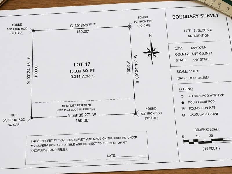
The Title Block
The title block is usually found in the bottom right corner of a survey plat. It contains key identifying information about the property and the survey itself.
Look for the following in the title block:
- The name of the property owner
- The address or legal description of the property
- The name and license number of the surveyor who certified the plat
- The date the survey was completed
- The scale of the drawing, such as 1 inch equals 50 feet
The scale is important. It tells you how to interpret distances on paper. If the scale is 1 inch equals 50 feet, then a line that is 2 inches long on the plat represents 100 feet on the ground.
The North Arrow
The north arrow shows which direction is north on the plat. This helps you orient yourself when comparing the drawing to the actual land.
Most plats use one of two north references. True north points toward the geographic North Pole. Magnetic north points toward the magnetic North Pole, which shifts slightly over time. The plat will usually note which type is being used.
Once you find the north arrow, you can figure out which side of your property faces which direction. This is useful when checking fence placement, planning construction, or comparing the plat to a map.
Boundary Lines
Boundary lines are the solid lines that outline the edges of the property. These are the most important lines on the plat. They show the legal limits of what you own.
Each boundary line has two pieces of information attached to it: a bearing and a distance. These tell you the direction and length of that line.
Bearings
A bearing describes the direction a boundary line runs. It is written using compass directions and degrees. A typical bearing looks like this: N 45°30’00” E.
Here is how to read it:
- The first letter (N) is the starting direction, either North or South.
- The number (45°30’00”) is how many degrees the line turns from that direction.
- The last letter (E) is which side it turns toward, either East or West.
You do not need to memorize the math. What matters is that every boundary line has a unique bearing that tells you exactly which way it runs.
Distances
Next to each bearing, you will see a distance in feet. A line labeled N 45°30’00” E, 125.50′ runs in that direction for 125.50 feet. Adding up all the distances gives you the total perimeter of the property.
Monuments and Markers
Monuments are the physical markers placed in the ground to mark the corners of a property. On a plat, they appear as small symbols at each corner. The legend explains what each symbol means.
Common types include iron pins or rods, and concrete posts. The plat will also note whether a marker was already there when the surveyor arrived (found) or placed during the survey (set). If your plat shows iron pins, you may be able to locate them with a metal detector.
Easements
Easements are shown on a plat as dashed or dotted lines running across or along part of the property. They are labeled with a description of what the easement is for and how wide it is.
Common examples include utility easements, drainage easements, and access easements. An easement line that runs along the back edge of a lot, labeled “10-foot utility easement,” means a utility company has the right to use that 10-foot strip of your land.
Knowing where your easements are helps you avoid building in spots where you do not have full control of the land.
The Legal Description
The legal description is a written paragraph that describes the property using the same bearings and distances shown on the plat. It reads like a set of directions that traces the boundary of the property from one corner to the next and back to the starting point.
Legal descriptions are used in deeds and other official documents. If the legal description in your deed does not match what is shown on your plat, that is a red flag worth investigating with your surveyor or attorney.
The Surveyor’s Certification
At the bottom of the plat, you will find the surveyor’s certification, signature, and official seal. The certification confirms that the survey was done to professional standards and that the information is accurate. Without this seal and signature, the document is just a drawing.
Frequently Asked Questions
What does “P.O.B.” mean on a survey plat?
P.O.B. stands for Point of Beginning. It marks the starting corner of the legal description. The boundary lines are traced starting from this point and return to it at the end.
What does it mean when a plat shows a gap or overlap with a neighboring property?
A gap means there is a strip of land between your property and your neighbor’s that does not belong to either of you on paper. An overlap means the two properties share the same area on paper. Both are errors that need to be resolved with the help of a surveyor and possibly an attorney.
Can I use my survey plat to place a fence?
Yes. Your plat shows the exact boundary lines and corner locations. Use it along with the physical monuments on the ground to confirm placement before building.
What is the difference between a plat and a deed?
A deed is a legal document that transfers ownership of a property and includes a written description of it. A plat is a drawn map that shows the same property visually. Both work together to define what you own.